Despite considerable evidence to disprove it, the Columbia Accident Investigation Board continues to claim that foam falling from the Shuttle
|
There is clear evidence that whatever caused the Columbia accident occurred at 13:50:00 GMT, just north of Hawaii over the central Pacific Ocean. That is shown by the almost simultaneous stopping of the astronaut's video along with the beginning of a series of strange repeated communication dropouts lasting from 1 to several seconds each. These still unexplained dropouts continued from 13:50:00, recurring 15 times and finally ending with the complete Loss of Signal (the LOS) at 13:59:32 somewhere over Texas. At that point in time Columbia was out of control and breaking into pieces. Something drastic had happened to Columbia's electrical system way back at exactly 13:50:00 over Hawaii.
Simultaneous with many of the communication dropouts was the firing of one of the left rear RCS jets which steer Columbia to the left. Since these uncommanded jet firings occurred only during the signal dropout periods, they were never seen by the people at Mission Control during the landing. Only later analysis shows that these firings occurred, since, as soon as the communication was recovered some seconds later, the nozzle temperature of that jet was hot, indicating it had just fired. For how long that jet fired is not known. Some of the signal dropouts were several seconds long. That was long enough, if one of the left jets were firing for that length of time, to have spun Columbia around.
No one at Mission Control was watching for warm RCS steering rocket nozzles since that wasn't important at the time. There was no data at Mission Control which showed any uncommanded steering jets firing. What was seen was a strange "drag" on the left side. But maybe it was not a drag. It was probably the uncommanded and unseen firings of the left rear steering jet which turned Columbia to the left. Then when communication was restored some seconds later the data shows that Columbia was then steering to the right, as if to recover from a strange drag to the left.
Ultimately it was most probably the uncommanded firings of the left rear steering jets which caused Columbia to enter an out-of-control spin to the left and resulted in the Orbiter breaking apart at an altitude of 38 miles.
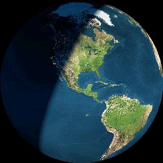
fig. 7 Earth at 8:00 am CST, Feb 1, 2003 as Columbia was Landing. This graphic shows the west still in dark, Texas in sunlight and the "terminator" across New Mexico. |
If the CAIB did hear testimony about the repeated signal dropouts and the uncommanded firings of the left steering jet, it was during that "secret" meeting held with NASA personnel when they testified as to NASA's theory of what caused the Columbia accident. But CAIB Chairman Adm. Gehman has stated, "That testimony will never see the light of day."
Instead the CAIB has embarked on a campaign to denigrate NASA, to demoralize the NASA organization, and to blame the loss of Columbia on NASA's sloppy policies, procedures and management. I believe none of these are accurate. The CAIB has clearly attempted to sweep the evidence under the carpet and mislead the media and the public.
The primary goal of the board, as directed by Admiral Gehman, seems to be to hide any connection between the probable cause of the accident over the north Pacific Ocean and the final breakup of Columbia over east Texas. One simple way to do that is to arbitrarily shove all the anomalous events such as failing temperature and pressure sensors and place them as occurring over the US southwest just prior to Texas. In fact, other evidence shows most of those strange events occurred over the Pacific Ocean just before reaching California. But to do that moving of the events the CAIB must produce a "bogus" time line. The events are placed in the right order and at the right time but what has been changed and stretched out is the actual location of these events.
There is no independent scientific corroboration of the time and location of these events other than what the CAIB has told the public in it's official
CAIB OFFICIAL
TIMELINE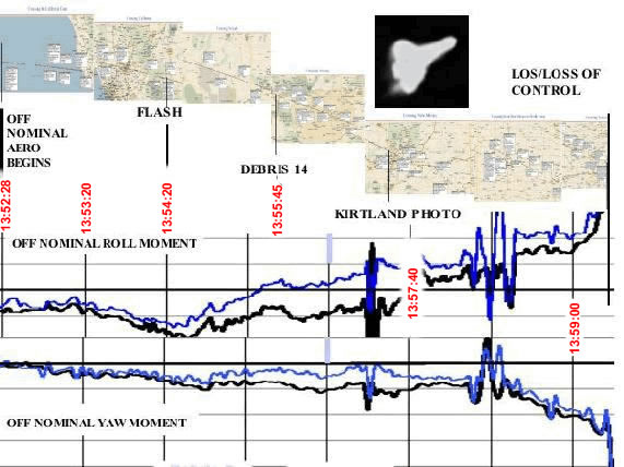
fig. 8 Preview of the Official Timeline from CAIB Report April 8, 2003. |
If you wish to see the actual "Official CAIB Timeline" you can view a Spreadsheet Version of Rev 15 in excel format, or a Graphical Version in pdf format which includes notes added on top of a large map. Both versions indicate times and locations of citizen observations and videos which are referenced to an "Atlas" of observations which I have not seen, nor can I find.
At several points in the Timeline the location of the events is referenced to a data source called "STS-107 GPS Trajectory Data." This document seems to be unavailable. And curiously the STS-107 location data, supposedly based on GPS tracking data, seems to be exactly the same as the STS-5 Trajectory Profile.
The STS-5 profile was a complete set of tracking data from the fifth flight
NASA STS-5 Trajectory
Profile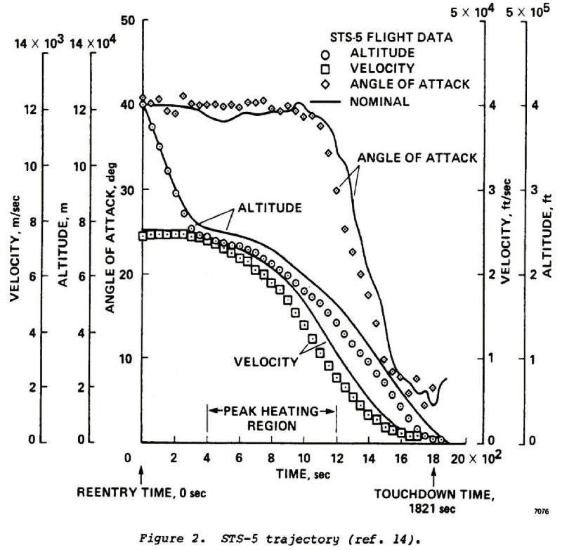
fig. 9 NASA Trajectory Profile for STS-5, Columbia Nov 16, 1982, Based on the OPS 304 Computer Landing Program, Showing Flight Parameters from Entry Interface with the Atmosphere Down to the Point of Landing. |
The ionized plasma surrounding an orbiter during the peak heating region of reentry causes a 16 minute communication blackout period. This lack of communication problem was solved in 1989 when the second TDRS communication satellite was placed in stationary orbit above Hawaii. Since then a continuous data link from an Orbiter to Mission Control is maintained by using the transceiver antennas just above the Orbiter's front windows and looking backward through the "hole" in the plasma trailing behind the Orbiter aimed at that TDRS satellite in the direction just above the Orbiter's tail.
The communications blackout problem was solved but the plasma problem still exists and thus blocks communications from anywhere outside that narrow hole
THE GPS SATELLITE
SYSTEM
fig. 10 The GPS Constellation of 24 satellites. This is also called NAVSTAR by the Military. (Picture courtesy of Garmin Ltd.) |
If GPS receiver data is lost, the orbiter can always rely on its older inertial guidance system. But those gyroscopic accelerometer devices are seriously thrown out of whack when speeding up and slowing down and while doing turning and twisting maneuvers at the same time. And that is exactly what Orbiters do while decelerating into the atmosphere and doing the programmed 60 degree back-and-forth yaw and roll maneuvers to dissipate heat during landing. Thus the supposed document "STS-107 GPS Trajectory Data" which is the basis for the CAIB's Timeline, must be 'iffy" at best. And completely made out of "whole cloth" at worst. In other words, the old STS-5 position and time data could be inserted into the "STS-107 GPS Trajectory." And who would know, since, other than the military, who has any independent tracking data of Columbia's reentry?
CAIB TIMELINE
GRAPHIC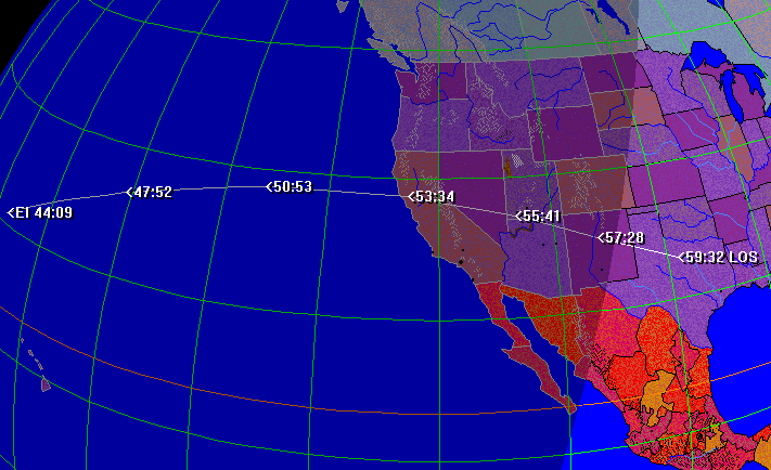
fig. 11 Timeline data taken from CAIB Timeline Rev 15.S |
To prove it, I am going to give you a snippit of the testimony given before the CAIB on Monday, March 17, 2003. Among those testifying was Paul Hill, a missions operations director for the Shuttle Program, a flight director for the the Space Station, and Mr. Hill was on the Mission Response Team (MRT) investigating the Columbia accident for NASA. His role on the MRT was to lead a group called the Video Sightings Assessment team. He and his team collected the many thousands of observations, photos, videos and other related data showing Columbia coming over the southwest US.
I should note here that in all of the CAIB hearings, nobody was "sworn in" or notified that they swore to tell the truth under penalty of perjury. They were simply asked if they were telling the truth, to which, of course, everybody says, "Yes." That was just to make everybody feel "comfortable" during the hearings. So take the words "testify" or "testified" with a grain of salt.
Mr. Hill testifies: "... we're trying to make some sense out of the public imagery and any external sensor data that we can get our hands on to tell us what was happening to us as early in reentry as possible and maybe shed as much engineering information as possible on what was going on with the vehicle before we knew what was happening on the ground."
Paul Hill, gave a lengthy and detailed description of the collection process and how they weeded out the meaningless, useless or obviously hoaxed videos and pictures. One example was a video of car headlights coming down a distant mountain road. Mr. Hill described the matching of the videos with observations of debris falling from Columbia and how they were carefully documented and added to the CAIB Timeline.
Paul Hill ends with, "And without the public having taken these pictures... and these folks got up before sunrise and went out on their own and stuck their cameras up in the sky and most of them also knew exactly where to look in the sky because we knew they were amateur astronomers - without those folks, we wouldn't know any of this. I mean, these people are definitely our heroes..."
After applauding the public for their interest and support in taking all those videos and pictures, CAIB Chairman Admiral Gehman adds, "We join you in being thankful for that. We're also thankful for a crystal-clear morning across the entire southwest part of the United States."
And therein lies the problem. There were no "crystal-clear" skies across the southwest on the morning of Feb 1, 2003 as Columbia was landing. In fact, about 95 percent of the groundtrack of Columbia crossing California, Nevada, Arizona and New Mexico was in a severe winter storm condition, ranging from overcast skies to snow squalls and blizzard.
NOAA INFRARED PHOTO 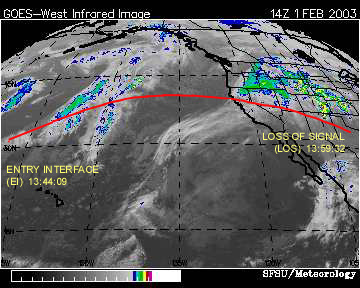
fig. 12 Satellite Photo Showing Massive Winter Storm Over California, Nevada, Arizona and New Mexico. Columbia's Orbital Reentry Feb 1, 2003 Shown in Red. |
This graphic is the NOAA GOES West weather satellite picture snapped at 1400Z which is Greenwich Mean Time or Military Time for 8:00am CST or 6:00am PST. This picture from Feb 1, 2003 was taken as Columbia was over central Texas, according to the CAIB. This picture shows a massive winter storm covering most of the west and southwest United States. In an earlier article I showed this same graphic which I published on Feb 8, but I located Columbia as being over central Nevada. That was based on the time of passage given to me by NASA in an email sent Jan 29 to alert me of the coming overflight of Columbia that next Saturday.
Either way, whether Columbia is over Nevada or Texas, the Orbiter is in this satellite picture if somehow you could see it. And this is no lightweight storm covering most of the western states. The picture includes colored sections added by NOAA near the storm centers indicating various severe degrees of precipitation or snowfall. This very same storm on Feb 1, later became the now famous east coast storm that dropped several feet of snow all the way from Florida to New England. The southern states, especially Georgia and Florida were not prepared. They don't have fleets of snowplows to scrape away several feet of snow.
You may remember that date was Feb 4, if you live on the east coast, and that was the same massive storm as this western storm which just days earlier is drawing millions of tons of water vapor from the warm and wet Pacific just east of Hawaii. The result was, especially at night when the air temperatures cooled, all that moisture turned into clouds and overcast, even if it wasn't snowing or raining. But later satellite pictures show that each day just hours after the sun rose over the western US, and the air temperature warmed, that overcast seemed to clear up a bit, but was still there as a high thin haze over a blue sky. That day-haze and night-overcast over the west later became the snow that blanketed the east.
Actually at that time, NASA Mission Control did have a pretty strong clue and sneaking suspicion. Among many other items in the Mission Control audio transcript, just before closing shop and locking up the doors at Mission Control, Flight Director Leroy Caine asked on the NASA intercom, "Has anybody heard anything from Space Command?" Whether he got any answer is not really clear since that was pretty much the end of the 'official' NASA transcript of the Mission Control audio. Certainly the Air Force Space Command has a complete record of all objects and events in space, but none of that record has ever been given to NASA, or the public. It is not in the CAIB record of entered evidence in the Columbia hearings. Maybe the CAIB and it's Navy Admirals and Air Force Generals didn't bother to ask Space Command if they had any data. Maybe they were told they didn't want to know. Don't ask, don't tell.
There is at least one mention in the CAIB hearings that an unidentified DOD (Department of Defense) asset did have a record of an "external event" which happened to Columbia northeast of Hawaii at 13:50:00. What is an "external event"? And who recorded it? The CAIB Timeline shows this event as: "Remote sensors indicate off-nominal external event -- L2L, L3L, and R2R jet firings occurred near event." It turns out the CAIB's reference to "remote sensors" seems to always be some military DOD facility which is not named, probably for "national security" reasons.
Most probably here, given the time, it would be the Navy's Pacific Missile Range Facility (PMRF) on Kauai, Hawaii, which has a long range over-the-horizon radar system for tracking missiles and space objects covering Asia and the Pacific Ocean. The Navy's PMRF is the eyes and ears in space for the Air Force Space Command. What the Navy Kauai radar may have seen as Columbia passed by at 13:50:00 we will never know, since two days later on Feb 3, 2003 the Navy was ordered to erase all hard-drives and data tapes at the PMRF. Is this standard Navy practice? How convenient for the Columbia investigation board, which was appointed just 90 minutes after the Columbia disaster on Feb 1.
And isn't it coincidental that "external event" occurred at exactly the same moment as the stopping of the astronaut's video, the beginning of the unexplained communication dropouts and the repeated uncommanded firing of the left rear steering rocket? I will be explaining more about that DOD report later.
Later that same day, the news and even the Internet was abuzz with rumors and stories of many strange Columbia sightings. One of the early sightings was the now famous "San Francisco photographer" who had a picture of Columbia with strange lightning or some jagged light shooting off its tail. The San Francisco Chronicle played that story to the hilt with daily reports but no actual picture. NASA even sent an astronaut to recover the "photographer's" camera with the picture. That story spawned all kinds of whacko theories about directed energy weapons, solar generated plasma sheets in the ionosphere, strange lightening from elves and sprites, etc.
Obviously the hoaxers didn't get out of bed before 6:00am to see Columbia and didn't know that it had been overcast and stormy over northern California. They probably watched the TV coverage for an hour or so until the skies were clear then thought they would put in their two cents by producing hoaxed reports, pictures and videos. They thought they could get away with it since they didn't know it had been completely overcast as Columbia passed by. The many videos from Dallas, Texas showed fairly clear skies, but with some high haze. Later that morning even California, Nevada and New Mexico seemed to clear up with also only a high haze. Since it had been clear weather in California for the previous several days, the Californians thought it must have also been clear as Columbia went by.
Several days later, I sent an email to the Chronicle writer who was producing the "SF photographer" stories and I attached a copy of the NOAA weather picture proving that nobody in San Francisco could have seen Columbia nor taken any picture. I never heard back from the writer. The Chronicle instantly dropped the story. They knew then that they had been hoaxed.
If you heard about that early story of the SF "photographer" and his amazing photo, but then wondered why you never got to see the real picture, no, it was not some kind of military cover-up of some new space zapper weapon. It was simply I had exposed the hoax to the Chronicle writer. And rather than fire the writer for silly and sloppy reporting, and printing a retraction, the Chronicle simply dropped the story. That is called a media cover-up.
If the Chronicle had printed a retraction explaining the hoax, it would have been embarrassing, but that would have put an instant stop to all the many similar hoaxes which showed up days later. Instead, the Chronicle said nothing about overcast conditions. Hundreds of copy-cats got to work with their PhotoShops and PC-video editors and produced many delightful but fraudulent "videos of Columbia." The hoaxers had never read in the Chronicle that no California observations were possible because of the complete overcast along Columbia's ground track. I had reported it on Feb 8, but it seems not everybody in the world had read the Brother Jonathan Gazette. And certainly not the hoaxers.
Most people have assumed that for several years now, you can't trust photographs anymore since with a computer you can hoax any picture you want. The Internet celebrity porn sites are filled with thousands of hoaxed but almost believable pictures. But what about home videos? Can they be hoaxed too?
If you wish, I can show you how to easily take some home video of the night sky, add a Space Shuttle, a Space Station, Soyuz capsule, UFO, or even a dented '97 Lexus with your name on it, passing right overhead. No problem. And what about that pesky documentary date and time-stamp in the corner of the video? No problem. Erase the old one and stick on a new one. When do you want to see your Lexus passing overhead?
It would seem then, that since videos can be so easily hoaxed, they are useless for documentary evidence of what happened to Columbia. NASA's Mr. Paul Hill, in his testimony to the CAIB did say, "...most of them also knew exactly where to look in the sky because we knew they were amateur astronomers..." Well, I am an "amateur" astronomer along with being a physicist, engineer and a few other things. I have boxes of astro-photographs, of which I am proud, which I made going back to the mid-'60s.
One thing I know about today's "amateur" astronomers, most of them are among that special class of proud adepts called "computer nerds." And who know just enough about computers to morph the head of a Titan IV missile onto the body of Brittney Spears and have her dancing across Shuttle Columbia, whistling "One More Time" as she passes by Phoenix, Arizona, at any time you want.
I really don't think an amateur astronomer who knows how to convert space coordinates from equatorial to local angles above the horizon and runs the timer of his video camera on Universal Coordinated Time rather than local time, is someone I would trust not to make a hoaxed video. But that is how NASA and Mr. Hill qualified many videos as being legitimate.
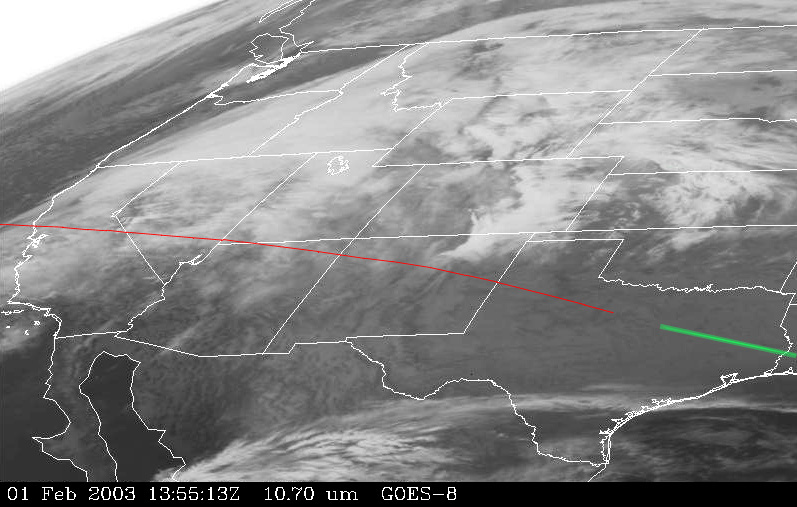
fig. 13 NOAA GOES-8 Satellite Photo Showing Massive Winter Storm Over California, Nevada, Arizona and New Mexico. Columbia's Orbital Reentry Feb 1, 2003 Shown in Red. |
I have included the groundtrack of Columbia in red and at the end is the area of the debris field found in east Texas and Louisiana. I will be showing you detailed parts of this picture later but I wanted you to see the whole picture. And I ask, do you really believe anybody along that red line was able to see Columbia either with the naked eye, camera or videocam? If not, then where did all those thousands of citizen reports, photos and videos come from? And how come none of those observers or videographers reported cloudy or partly cloudy skies? Hmmm??
If there are no valid citizen reports of the passage of Columbia at the times they specified, and if there were no valid reports of flaming objects and debris falling from Columbia, then what really did happen? And where did it happen?
If you can't trust the CAIB Timeline observations, and GPS data - how can you trust the CAIB to find the cause of the Columbia disaster? If you can't trust the public observations and videos in the Timeline as being legitimate, how can you believe that the CAIB has any credibility at all?
====================
After the initial admission of how the photo was supposedly made using a small home-type telescope and an old Mac computer driving some mirrors to track Columbia, no reporters or investigators have been able to reach the
|
Back in February and March, the photo was used to show some possible damage to the left wing. But even that is in doubt. So why is the CAIB still claiming that the Kirtland Photo is legitimate? For one reason only - to attempt to show that Columbia was still flying in one piece over New Mexico. I will show you that the Loss of Signal (LOS) and then the breakup of Columbia occurred closer to Nevada and Arizona, not after New Mexico. But the CAIB claims that the LOS and breakup occurred after Dallas, Texas. The CAIB needs this Kirtland Photo or the whole CAIB Timeline falls apart.
